Rivers, Major World
The size and importance of the world's rivers are measured in terms of discharge and length. A river's importance may also be measured in terms of local and regional water availability and population. A small river flowing through a densely populated, arid region may be extremely important, for example.
Rivers flow downhill from their sources to their mouths at the sea. The sources of the world's major rivers are often in highly elevated or mountainous areas, but there are exceptions. For example, the source of the Mississippi River is Lake Itasca, Minnesota, which lies only about 461 meters (1,515 feet) above sea level.
Although the world's major rivers flow through many different types of terrain, they provide similar physical and biological functions. Rivers transport sediments from their basins to the sea through the processes of erosion, transport, and deposition. In a river system's upland areas, erosion is the dominant process. Tectonic processes result in the uplift and formation of major mountain chains, while the world's major river systems help erode those mountains. For example, the Colorado River of the southwestern United States flows through the Colorado Plateau region. The Colorado River's world-famous canyons were created over millions of years as the river eroded its way downward through the Colorado Plateau, which was being driven upward by tectonic forces.
A river's flow is halted when it reaches the sea, where the river deposits its sediments and creates a delta. River deltas commonly assume a triangular pattern that resembles the Greek letter delta (Δ)—a letter based on the shape of the Nile River delta in northern Egypt. Fresh water and salt water meet in these deltas, which are some of the world's most biologically productive areas.
The world's major river systems are storehouses of biological productivity and diversity. Rivers and their floodplains provide habitat for aquatic and terrestrial species. Many of the world's large rivers experience an annual flooding cycle that is important for spreading water, nutrients, and sediment into floodplains as well as providing reproductive cues for fish.
Large dams for reducing floods and producing hydroelectricity have been constructed on many of the world's large rivers. Flood damage reduction works, such as dams and levees, encourage people to move into floodplains; however, the loss of this annual flood cycle often has had negative ecological consequences. Water resources managers and scientists around the world are exploring ways to restore parts of these annual flood cycles in order to restore natural river processes and habitat. Controlling the releases of waters from reservoirs to mimic natural flood patterns is a notion under discussion in many areas of the world.
Asia
The Yangtze ( Chang ) River of China is Asia's largest river in terms of discharge. Like many of Asia's major rivers, the Yangtze's headwaters are in central Asia's Himalaya Mountains. The Yangtze has a history of devastating
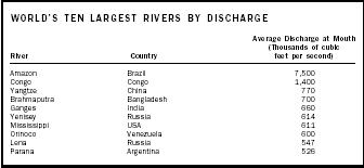
| WORLD'S TEN LARGEST RIVERS BY DISCHARGE | ||
| River | Country | Average Discharge at Mouth (Thousands of cubicfeet per second) |
| Amazon | Brazil | 7,500 |
| Congo | Congo | 1,400 |
| Yangtze | China | 770 |
| Brahmaputra | Bangladesh | 700 |
| Ganges | India | 660 |
| Yenisey | Russia | 614 |
| Mississippi | USA | 611 |
| Orinoco | Venezuela | 600 |
| Lena | Russia | 547 |
| Parana | Argentina | 526 |
floods; 3.7 million people were killed in floods in 1931, one of humanity's worst natural disasters. The Yangtze has gained attention as the site of the ongoing Three Gorges Dam project; when finished, it will be the world's largest hydropower dam. Potential negative effects of the dam include the resettlement of more than one million people and the submergence of large areas of scenic beauty and cultural significance.
The Brahmaputra River is the world's fourth-largest river, and the Ganges River the fifth largest. Both rivers have their headwaters in the Himalayas and, along with the Meghna River, merge in Bangladesh to form a river that has 2.5 times the discharge of the Mississippi River. Floods during the summer monsoon season in this river system are immense and often cause tens or hundreds of thousands of deaths. But the floods represent a paradox for Bangladesh, as the annual floods are essential to maintain soil fertility and fisheries.
Southeast Asia's Mekong River flows through six nations: China, Myanmar, Laos, Thailand, Cambodia, and Vietnam. The Mekong has been noted for its relative lack of development, although this is changing, as China is constructing dams on the upper Mekong River. The Mekong also is noted for sustained international cooperation on river basin planning in the lower basin. Today's Mekong River Commission represents an international organization that has existed in many forms since its establishment in the late 1950s.
The Indus River and its river basin represent one of the world's highly developed and regulated river systems, with a history of massive inundation canals dating back four millennia. The Indus flows from the western flank of the Himalayas in Tibet and then primarily through Pakistan on its way to the Arabian Sea, but several of its large tributary streams are in India. Expansion of irrigated agriculture in the basin continues, with gains in agricultural production offset by salinity, waterlogging, and flood losses.
Some of the world's large rivers are in Russia. The Yenisey (sixth largest), Lena (ninth), and Ob (thirteenth) Rivers are among the world's twenty largest rivers. All these rivers flow northward to the Arctic Ocean.
Africa
As Africa is the world's most arid continent, its rivers are of great importance. Most of Africa's rivers are characterized by annual climate cycles that alternate seasonal rainfall with seasonal drought. Fifty-four of Africa's river basins cross international borders. There is thus a need for international collaboration if these large African rivers are to approach their full potential in balancing the demands of meeting human needs and sustaining ecosystems.
The basin of the world's second-largest river, the Congo River, covers eleven western African nations. The world's longest river, the Nile, is in northern Africa; its river basin is shared by twelve nations. The Nile is well known for the ancient civilizations that inhabited its valley. The Egyptian civilization depended greatly on the Nile and the irrigated agriculture in its floodplains. The Nile flooded annually, and the silt from these floods replenished agricultural soils, and the water helped flush salts that had accumulated in the irrigated fields. In the 1960s, the Aswan Dam was constructed on the Nile River. Although the dam eliminated this annual flooding cycle, it has brought several benefits to Egypt, especially hydroelectricity.

Europe
Europe's largest river is the Danube, which flows eastward through more than a dozen nations on its way to the Black Sea. The Rhine River flows northward through several European nations before emptying into the North Sea. Both these rivers flow through many cities and are heavily used. Floods generally do not present problems in these rivers, but pollution is a concern in both of them. For example, a large chemical spill in 1986 in the upper Rhine killed fish far downstream, and prompted the formation of a pollution warning system along the river.
North America
The Mississippi River is North America's largest river. Joined by the Ohio River to the east and the Missouri River to the west, the Mississippi is the world's seventh-largest river when it reaches the Gulf of Mexico. The Mississippi is well known for its great floods. A great flood in 1927 initiated changes in federal water planning that have lasted for several decades. Even with improved planning and flood control, the 1993 Mississippi floods still caused widespread damage.
Canada and the United States share two of North America's great rivers: the Columbia and the St. Lawrence. The Columbia is in the Pacific Northwest, and its dozens of dams constitute the world's largest hydropower system. The Columbia also is famous for its legendary salmon fisheries and the conflicts between fisheries interests and operators of the hydropower dams. The St. Lawrence forms the boundary between eastern Canada and the United States and is the outflow of the Great Lakes to the Atlantic Ocean.
The Colorado River of the southwestern United States flows through an arid and highly populated region and is an important source of water for millions of people, especially in southern California and Arizona. The Colorado was well known for its wide variations in streamflow and the tremendous amounts of silt it carried to the Gulf of California. The Colorado has been so extensively dammed and diverted that it no longer reaches its mouth (terminus), instead drying up in the Mexican desert. Several environmental groups are currently investigating strategies for restoring these flows.
South America
South America combines the world's highest average annual rainfall values with the world's highest evaporation and is the site of the world's driest area (Atacama Desert) and the world's largest river, the Amazon.
The Amazon has its headwaters along the eastern flank of the Andes Mountains and drains the largest river basin on earth. The average flows of the Amazon are larger than the combined average flows of the world's next ten largest rivers.
Other large South American rivers include the Orinoco (eight largest), which flows northward through Venezuela, and the Parana (tenth largest), which flows through Brazil, Paraguay, Argentina, and Uruguay.
SEE ALSO Colorado River Basin ; Columbia River Basin ; Hydropolitics ; Integrated Water Resources Management ; International Cooperation ; Mississippi River Basin ; River Basin Planning ; Transboundary Water Treaties.
Jeffrey W. Jacobs
Bibliography
Jacobs, Jeffrey W., and James L. Wescoat Jr. "Flood Hazard Problems and Programmes in Asia's Large River Basins." Asian Journal of Environmental Management 2, no. 2 (1994):91–104.
Scudder, Thayer. "River Basin Projects in Africa." Environment 31, no. 2 (1989):4–9,27–32.
Van der Leeden, Frits et al. The Water Encyclopedia, 2nd ed. Chelsea, MI: Lewis Publishers, 1990.
White, Gilbert F. "The Environmental Effects of the High Dam at Aswan." Environment 30, no. 7 (1988):5–11, 34–40.
Internet Resources
Wolf, Aaron T. et al. "International River Basins of the World." International Journal of Water Resources Development 15(4), Dec. 1999. Available online at <http://www.transboundarywaters.orst.edu/publications/register> .
Now, the river condition is not good. I hope all the people (include the expert) can give your contributions, how to manage our rivers, with our condition and culture. For information, we have little data,we have little equipment to measure river condition (discharge, sediment etc)and my knowledge still limited.