Ocean Currents
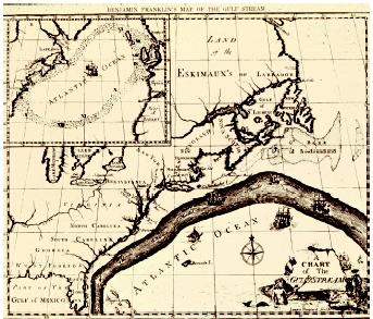
Mariners have known for many centuries that the ocean contains currents that flow along generally consistent paths. The Spanish galleons transporting gold and silver from Mexico to Spain made use of the Gulf Stream to help them return home, while Benjamin Franklin used ships' log books to draw a map of this current in 1772 (see illustration on page 139 based on his original map). Since then, scientists have gained much more information on both where currents flow and why.
Why Do Currents Flow?
Currents exist at all depths in the ocean; in some regions, two or more currents flow in different directions at different depths. Although the current system is complex, ocean currents are driven by two forces: the Sun and the rotation of the Earth.
The Sun affects the ocean in two ways. First, it heats the atmosphere, creating winds and moving the sea surface through friction. This tends to drag the water surface along as the wind blows over it. Although the wind strongly affects the surface layer, its influence does not extend much below about 100 meters (325 feet) in depth.
The second effect of the Sun is to alter the density of the ocean surface water directly by changing its temperature and/or its salinity . If water is cooled or becomes saltier through evaporation, it becomes denser. This can result in the water column becoming unstable, setting up density-dependent currents, also known as the thermohaline circulation.
The rotation of the Earth also affects the currents through the Coriolis force. This force causes water to move to the right in the Northern Hemisphere and to the left in the Southern Hemisphere. It exists because moving ocean water is affected by friction with the Earth only at the seafloor, and because the eastward linear velocity of the earth decreases from a maximum at the equator to zero at the poles (the rotational velocity, however, does not change). A parcel of water at the equator is moving at the same speed as the Earth. If it starts to move north, with no friction, it is then going faster than the Earth beneath it. To conserve momentum (the product of mass and velocity), it consequently moves more to the east as it gets farther from the equator. The Coriolis force therefore increases away from the equator.
Ekman's Theory.
The first reasonable theory of how the wind affects surface currents was derived by Swedish oceanographer and mathematician Valfrid Ekman in 1890. Ekman considered an infinitely wide and deep ocean of constant density, divided into an infinite number of horizontal layers. The top layer is affected by the wind and by friction with the layer below it. The second layer is also affected by friction at top and bottom, and so on. The Coriolis force also affects the layers because they are moving.
Balancing the friction and the Coriolis force led Ekman to conclude that the resulting currents decreased exponentially with depth, that the surface current moved at a 45-degree angle to the wind direction, and that deviations from the surface wind direction increased with depth, forming a spiral (to become known as the Ekman spiral). Adding the movement at all depths gives a mean (average) current that moves at right angles to the wind direction, to the right in the Northern Hemisphere, and to the left in the Southern Hemisphere. Such Ekman spirals are rare, but have been observed in the ocean.
Because the oceans are neither infinitely wide nor of constant density, as Ekman assumed, complications arise at the boundaries, where water tends to "pile up." The surface of the ocean is then no longer flat, but has a slope, which sets up a horizontal pressure gradient. The combination of the Coriolis force and the horizontal pressure gradient produces a current that flows at right angles to the pressure gradient; when the two forces are equal, this is known as a geostrophic current. All major current systems in the ocean can essentially be considered geostrophic.
Because the density of the ocean varies both horizontally and vertically, scientists can use the density structure of the ocean to calculate the pressure field and hence the pressure gradient. The result is a map showing how the height of the sea surface at any given point varies relative to a particular pressure level; relative changes in these dynamic heights are used because the seafloor is neither flat nor of constant depth. These maps can be used to show where currents flow (the steeper the gradient, the faster the current). Scientists can also use the observed density distribution in the ocean to calculate current speeds.
Patterns of Surface Currents
The general pattern of surface currents in the ocean is shown in Figure 1. This shows a series of quasi-circular gyres, or large eddies, in each ocean basin . The gyres tend to be biased towards the western side of the basin, where strong, narrow flows are found in the Gulf Stream, Kuroshio, Agulhas, Brazil, and East Australian Currents, which flow at speeds up to 2.5 meters per second (6 miles per hour). The volumes involved in these western boundary currents are large; the Agulhas, for instance, carries about 80 Sverdrups of water in the upper 1,000 meters (about 0.6 mile). Current speeds away from the western boundaries of the gyres are generally much lower, and currents on the eastern boundaries of ocean basins are much wider.
The gyres rotate clockwise in the Northern Hemisphere and counterclockwise in the Southern Hemisphere because of the Coriolis force; in this they follow the prevailing wind patterns. The northern Indian Ocean is an exception because of the intense atmospheric monsoon system that changes its direction twice a year, but an intense circular current system, the Great Whirl, develops off Somalia during the southwest (summer) monsoon.
The gyres in both ocean and atmosphere help to transport heat away from the equator towards the poles (the Gulf Stream keeps northern Europe
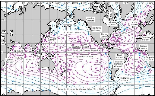
In two regions of the globe the surface currents do not form gyres. The Southern Ocean is a region of continuous westerly winds and is the only place on the globe where a continuous circumglobal current (the Antarctic Circumpolar Current) can form. This current therefore is a major region for mixing water between different ocean basins. It is the largest current on earth, having a total volume flux of at least 120 Sv.
Gyral motion is also absent near the equator. Equatorial currents are also driven by the wind, in particular by the trade winds—from the northeast in the Northern Hemisphere and from the southeast in the Southern Hemisphere. However, the Coriolis force here is zero, even though it becomes significant within one degree of latitude north or south. The boundary between the two sets of trade winds is usually slightly north of the equator. The trade winds set up two westward-flowing currents north and south of the equator (the North and South Equatorial Currents), but because the southeast trades blow across the equator, this causes a divergence (upwelling) along the equator itself because of the change in direction of the action of the Coriolis force.
Between the two trade-wind belts is a region of generally light winds, known as the Doldrums. This allows water, which would otherwise pile up against the western boundary of the ocean in the Equatorial currents, to flow back eastwards in the surface Equatorial Countercurrent. There is also an eastward-flowing Equatorial Undercurrent, which forms a jet within the thermocline , driven by the horizontal pressure gradient . This system of eastward-flowing and westward-flowing currents is found in the upper 200 meters (650 feet) in all three oceans, although their distribution may change seasonally depending on the wind forcing. The equatorial undercurrents are much stronger than the surface currents at the equator, and can have flows of more than 50 Sv.
Deep Currents
Currents in the deep ocean exist because of changes in the density of sea water occurring at the surface. These density changes give rise to specific water masses, which have well-defined temperature and salinity characteristics, and which can be traced for long distances in the ocean.
When sea water freezes, much of the salt that it contains is frozen out, so that a layer of cold brine forms at the ocean surface. Being denser than the water below it, the brine sinks, entraining water as it does so, until it reaches a level where it has the same density as the surrounding sea water. This process takes place in several regions of the world's oceans, the most important being in the Greenland, Norwegian, and Labrador Seas in the Northern Hemisphere, and close to the Antarctic continent in the Weddell and Ross Seas in the south.
It is the dense waters formed by this process that set up the deep ocean current patterns. Water formed in the Weddell and Ross Seas spreads eastwards and northwards around Antarctica under the influence of the Coriolis force. As is the case with surface waters, most of the flow is concentrated on the western sides of ocean basins, but in this case movement is towards the north. In the South Atlantic Ocean, for instance, bottom water from the Weddell Sea can be identified flowing through the Argentine and Brazil Basins below 4,000 meters (2.5 miles) in depth; it eventually crosses the equator into the North Atlantic off the coast of Brazil. Similar effects are found in both the South Indian and South Pacific oceans, with the bottom waters being forced to follow the bottom topography .
Water masses formed in the Northern Hemisphere similarly flow southward. The deep water from the Greenland and Norwegian Seas fills up these basins until it spills over the ridges between Greenland, Iceland, and Scotland. From here it is forced to the right by the Coriolis force and follows the topography around the coast of southern Greenland and the Labrador Sea, eventually crossing under the Gulf Stream and flowing south along the east coast of the U.S. at depths between about 2,000 to 4,000 meters (1.3–2.5 miles). This water, known as North Atlantic Deep Water (NADW), continues south until it joins the Antarctic Circumpolar Current, from where it supplies much of the salt to the deep waters of the southern hemisphere.
The Labrador Sea is also a source of dense water. Since, however, the winter conditions are not as severe here as in the Greenland and Norwegian Seas, the brine produced is less dense and does not sink as deep (only 1,500–2,000 meters, or 0.9–1.3 miles). However, the Labrador Sea Water can be traced southward in the North Atlantic as far as the equator on top of the NADW layer.
Role of Water Masses.
All these water masses help to transfer oxygen from the atmosphere into the deep ocean. The sinking water is very cold and contains high concentrations of dissolved oxygen acquired at the surface, because cold water can hold more oxygen than warm water. During their flow, they mix with "older" water that has been away from the surface for a longer time, thus ensuring that the bottom waters of the ocean are supplied with oxygen. Additional oxygen is supplied in the southern hemisphere by Antarctic Intermediate Water, formed in a band near 50° S to 55° S latitude. In this region, water does not freeze in winter, but it does cool forming a lowsalinity layer that sinks to about 1,000 meters (0.6 mile) depth and moves north in all three oceans.
Water need not be cooled to change its density. Large density changes also can be produced in areas where evaporation is more important than precipitation. Examples of regions where this occurs are the Mediterranean Sea, the Red Sea, and the Persian Gulf. Although the waters here are warm (in the Persian Gulf temperatures can exceed 30°C, or 86°F), the density can increase so that water leaving these enclosed basins sinks as it mixes into its surroundings. Mediterranean Water can be traced across the North Atlantic because of its high salinity, while Red Sea Water can be followed moving south along the east coast of Africa to the Agulhas Current.
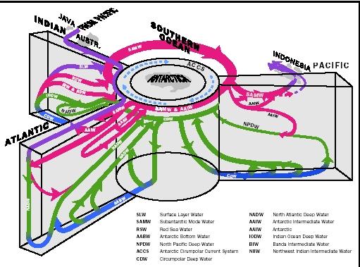
An idealized version of the current patterns throughout the whole ocean is shown in Figure 2. This shows clearly that although the surface and deep current patterns may appear separate, they are actually closely linked. Deep water sinking in the northern North Atlantic is replaced at the surface by warmer water from nearer the equator. Similarly, the dense water forming off Antarctica is replaced by upwelling of deep water derived originally from the North Atlantic. Thus, there is a global thermohaline circulation that converts surface water in high latitudes into deep water that moves away from its source, mixing with the water into which it flows.
This flow can be traced from the northern North Atlantic, through the South Atlantic into the Circumpolar Current, and then back again via upwelling in the Pacific and Indian Oceans to the surface layers. Water flows from the Pacific to the Indian Ocean through the Indonesian passages, and the circuit is completed by warm water in the Agulhas Current south of Africa, which enters the South Atlantic and moves northward, crossing the equator again and merging into the Gulf Stream. Although this pathway can be traced in Figure 2, it is clearly much more complicated than stated here. The currents do not flow continuously, as there are many small gyres where water gets "stuck" on its journey and is forced to recirculate one or more times before it can continue around the globe.
Similarly, there is considerable variation in the paths traced out by the different currents. While the general path of a particular current is the same from one year to another, the actual path it takes can vary widely on scales of a few weeks. All the western boundary currents show considerable movement about their mean position. Quite why these occur is not really known, but they may be driven by changes in the wind stress upstream, or the shedding of eddies.
SEE ALSO Climate and the Ocean ; Coastal Ocean ; Energy from the Ocean ; Navigation at Sea, History of ; Ocean Mixing ; Oceanography, Physical ; Oceans, Polar ; Sea Water, Gases in ; Weather and the Ocean .
Piers Chapman
Bibliography
Open University Course Team. Ocean Circulation. Oxford, U.K.: Pergamon Press, 1989.
Pond, Stephen, and George L. Pickard. Introductory Dynamical Oceanography. Oxford, U.K.: Pergamon Press, 1983.
Schmitz, William J. On the World Ocean Circulation , Vols I and II. Woods Hole Oceanographic Institution Technical Reports WHOI 96-03 and 96-08M. Woods Hole, MA: WHOI, 1996.
Tomczak, Matt, and J. Stuart Godfrey. Regional Oceanography: An Introduction. Oxford, U.K.: Pergamon Press, 1994.
STOMMEL MODEL
In 1948, Henry Stommel explained how friction, a rotating Earth, and a varying Coriolis force produced the strongest surface currents along the western boundaries of the ocean. A decade later, he modeled the deep circulation. He assumed that cold, dense water sinks only in restricted regions of the North Atlantic and Weddell Sea, but that the rising water replacing it does so throughout the tropics and subtropics. This theory requires strong deep flows towards the equator along the western boundaries of ocean basins, rather than away from it as at the surface. Recent observations have shown that these flows can exist east of midocean ridges as well as along the western boundaries of each ocean.
Who ever made this site is a smart smart person!!