Oceanography from Space
The use of space satellite data for ocea n observations allows marine scientists to view biological, chemical, and physical interactions within the oceans on regional and global scales. Satellite studies have revolutionized our ideas of how the ocean works. Satellite sensors measure a myriad of different phenomena including: sea surface temperature, surface wind, ocean color and productivity, ocean height, tides, and currents.
Altimeter Data
Several different in struments are used to collect oceanographic measurements. For example, the TOPEX/Poseidon satellite measures the height of the sea surface using an altimeter . The altimeter flies aboard the satellite at approximately 1,335 kilometers (830 miles) above Earth and emits a radar pulse that reflects off the sea surface. Because the speed of the pulse and location of the satellite are known, scientists can calculate the height of the sea surface.
In addition, the strength of the radar signal depends on the size of the surface ripples, which are in turn related to the wind speed, allowing the wind speed to be calculated. Because currents are detectable as slopes in the sea surface, the world's ocean currents can also be identified and monitored.
Altimeter data is also used for identifying the topography of the seafloor. For example, when there is a topographic high, such as a mountain on the seafloor, then there is a related topographic high or "mountain" in the sea level. This seafloor feature can be a subsurface seamount , or it may be a local increase in density in the Earth's crust.
Radiometer Data
A radiometer can be used to collect surface temperature data and ocean color data. A radiometer measures the amount of the Sun's visible light and infrared radiation reflected off the ocean. Examples of radiometers include the Coastal Zone Color Scanner (CZCS) and SeaWiFS (Sea-viewing Wide Field-of-view Sensor).
The temperature of the sea surface can be calculated using the infrared portion of the data. Because currents and water masses vary considerably in
Eddies are one feature in particular that can be identified using an infrared radiometer. These are generated by large-scale currents, such as the Gulf Stream. Eddies can affect the distribution of marine life and can last for many years before dissipating. Locating such eddies and studying their dynamics can help researchers track pollution such as oil spills and determine where marine life may be located.
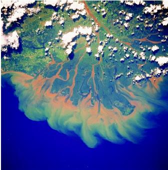
Ocean Color.
Ocean color can be determined by measuring the portions of the visible spectrum reflected from the ocean surface. It can indicate a number of things to an oceanographer, such as amount of plankton and amount of vegetation. The color of the ocean changes slightly, from a bright blue to a dark blue or black when plankton float freely or concentrate in areas. These concentrations are called blooms. These colors can indicate to scientists the productivity of the oceans and potential for greater amounts of wildlife since plankton are the basis of the marine food web and without plankton all marine life would suffer.
Satellite data have become accurate and dependable enough that they is now integrated with other forms of marine data collection. In addition, satellite data provide a large-scale view of ocean dynamics that otherwise would be unavailable. What has emerged is exciting new information about vast areas of previously unstudied open water.
SEE ALSO Algal Blooms in the Ocean ; Ocean Currents ; Ocean-Floor Bathymetry ; Ocean Mixing ; Weather and the Ocean .
Alison Cridland Schutt
Bibliography
Mellor, George L. Introduction to Physical Oceanography. New York: Springer Verlag, 1996.
Ross, David A. Introduction to Oceanography, 5th ed. New York: HarperCollins College Publishers, 1995.
Sandwell, David T. "Geophysical Applications of Satellite Altimetry." Reviews of Geophysics. supplement (1990):132-137.
SATELLITE PHOTOGRAPHS
This encyclopedia contains several photographs taken from satellites. Entries with notable images include:
- "Algal Blooms in the Ocean"
- "Bays, Gulfs, and Straits"
- "Geospatial Technologies"
- "Marginal Seas"
- "Microbes in the Ocean"
- "Ocean Mixing"
- "Ocean-Floor Sediments"
Comment about this article, ask questions, or add new information about this topic: