Wetlands
The very word "wetland" indicates that water is the first requirement for wetlands to exist. A wetland can be identified by three basic factors: soil, vegetation, and water regime (hydrology). A wetland generally is described as an area where water is the dominant factor in determining the nature of soil development and the types of plant and animal communities living in the soil and on its surface. Specifically, a wetland is an area that is periodically or permanently saturated or covered by surface water or groundwater , that displays hydric soils (unique soils associated with extended saturation), and that typically supports or is capable of supporting hydrophytic (water-loving) vegetation.
Occurrence and Characteristics
Wetlands form in areas where one or more of the following occur:
- The land is flat and water runs off the surface very slowly;
- Water becomes ponded in land-surface depressions;
- Infiltration of precipitation into the soil is slow;
-
Groundwater discharges to the land surface; or
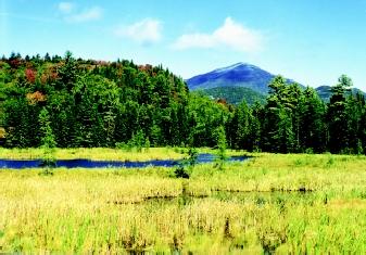 Although many people associate wetlands only with river floodplains and other low-lying areas, they can occur in mountains, high plains, and other elevated terrain. Freshwater marshes, such as the one shown here in Vermont's White Mountains, are distributed worldwide and form in a variety of settings.
 - The water table (the upper surface of the saturated zone of an unconfined groundwater system) is at the land surface.
In the broadest sense, all wetlands fall between two extremes with respect to where they get their water. On the one hand, wetlands may receive most of their water supply from precipitation. On the other hand, they may receive most of their water from groundwater discharge. One type of wetland that receives most of its water from precipitation is a vernal pool. These temporary pools dry up when precipitation is lacking. A different type of wetland, and one that receives most of its water from groundwater discharge, is called a fen. Fens usually occur in low areas, such as at the base of hillsides or in land-surface depressions. Wetlands that are present along streams, called riverine or riparian wetlands, fall between these two extremes because the source of water to a stream depends on precipitation in upstream areas and groundwater inflow to the stream–wetland system.
Plant and Animal Communities.
The type of soil development and the plant and animal communities that are supported depend on the depth of water and the length of time it is available, known as its hydroperiod. Where water is present most of the year, wetlands tend to be dominated by softstemmed herbaceous vegetation and grasses. Where water will be present only for a brief time, and where soil surfaces will dry long enough to allow germination of woody species, brush or trees will be the dominant vegetation. In areas of restricted drainage, the accumulation of partially decomposed sphagnum moss and other acid-loving plants builds up deep peat layers.
Submerged aquatic plants, which are those that grow completely underwater, usually grow in the part of the wetland where the water is deepest. Emergent aquatic plants, which are those that have the lower part of the plant underwater but the upper part above the water, grow where the water is shallower. Some wetland plants near the edge of water do not actually grow in water, but they are considered to be wetland plants because their roots are in the saturated soils directly adjacent to the water.
Wetland plant communities generally have distinctive patterns called zones. For example, in the wetlands that are in land-surface depressions, such as in glacial terrain, the zones generally have a concentric pattern. The open-water zone where the submerged plants grow is in the middle. This is sometimes also called the deep-marsh zone. This zone is surrounded by the shallow-marsh zone where the emergent plants grow. Beyond the water's edge is the wet-meadow zone. Wetlands along streams have similar plant zones, also depending on water depth. Wetlands in flat, coastal areas generally do not have such distinct plant zones because the vast flat areas commonly are covered by only one plant type.
Just as water provides the basic conditions for the distribution of plant zones in wetlands, the plant zones themselves provide habitat for animals. Certain microorganisms and invertebrate animals can be found in some plant zones but not in others. Other animals, usually the more mobile ones, such as waterfowl, use all the plant zones, but for different reasons. For example, some plants provide food for waterfowl, but other plant zones provide shelter and nesting sites.
Wetlands contain some plants and aquatic animals that live only in wetlands and that are different from those living in upland areas. However, some upland animals occasionally use wetlands for food and shelter. For these reasons, wetlands are important ecosystems in their own right, and also are important parts of the larger natural environment.
Wetland Classification
"Marsh," "swamp," and "bog" are some names commonly used to identify wetlands. Other names for types of wetlands include bottomland, fen, mangrove, mire, moor, muskeg, peatland, playa, pothole, reedswamp, slough, swamp, vernal pool, wet meadow, and wet prairie.
To wetland scientists, these terms can be used to identify specific wetland types. But because of the diversity of wetlands, descriptive schemes based on landscape position have been developed to identify broad wetland systems. Wetlands at the ocean's edge are marine systems, whereas wetlands in estuaries (where rivers meet the ocean) are estuarine systems. Wetlands along the edges of rivers and streams are riverine or riparian systems, and wetlands along the edges of lakes are lacustrine systems. Upland wetlands not connected to rivers or lakes are palustrine wetlands.
Water supply, and consequently, vegetation and soils vary for each of the systems. Marine systems are dominated by tides. Estuarine systems are influenced by the interaction of tides and river flows. Riverine systems reflect the controlling role of flooding from high flows, while the water supply for lacustrine systems depends on the lake level and the water supply to the lake. Palustrine systems usually are dominated by rain and snowfall. As noted previously, groundwater may play an influential role in any of these systems, depending on the local geological situation.
The different types of places where wetlands can be found can be divided into six groupings of terrain: mountains, plateaus and high plains, playas, river valleys, coastal, and glacial and dune.
Mountains.
Mountains have small uplands and lowlands separated by large, steep valley sides. Wetlands in mountains generally form in the narrow flat
Plateaus and High Plains.
Plateaus and high plains have broad, extensive uplands and relatively small, narrow lowlands in the river valleys. Wetlands in plateau and high plains landscapes generally are restricted to the valley bottoms along streams. The wetlands in the valleys receive water from the stream and from groundwater discharge to the stream valley. If riparian wetlands are dependent primarily on the stream, they are dependent on precipitation in their upstream watershed. If wetlands in river valleys are dependent primarily on groundwater discharge, the size of the groundwater flow system is the primary consideration in determining their source of water.
Playas.
Playas are extensive, flat lowlands that do not have streams draining them. The source of water to wetlands in playas is largely from stream flow that originates from precipitation in the surrounding uplands. Groundwater and precipitation directly on the wetland generally are much smaller contributors of water.
River Valleys.
Large river valleys have relatively wide lowlands. The source of most water to the riparian wetlands along the river is the river itself, but groundwater also discharges to the wetlands along the river as well as to other wetlands across the valley bottom not connected to the river. Floods also cause some types of wetlands to form in river valleys. Even without floods, other types of wetlands form when high river levels cause water to move sideways through the stream banks and fill depressions in the floodplain. For these types of wetlands, changes in the level of the river cause changes in water level in the wetlands.
Coastal.
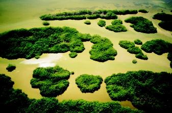
Many coastal plains have broad, flat areas. Perhaps the main reason why wetlands occur in flat coastal areas is the low slope of the land surface. Broad, flat lowlands commonly have slow runoff and also tend to have shallow water tables. Groundwater discharges to wetlands across the broad flatlands, but probably most groundwater discharges near the edge where the plains meet regional uplands. Wetlands in flat coastal areas are among the most extensive wetland systems in the world.
Glacial and Dune.
Glacial landscapes are parts of the Earth that were covered by glaciers during the last Ice Age. Glacial landscapes have isolated depressions that can have a wide variety of shapes and sizes. Wetlands often form in the depressions in such landscapes if the water table is close to land surface. Most of the depressions do not have streams entering or leaving them; therefore, streamflow generally is not a major source of water to the wetlands. Wetlands in these areas receive their water supply from precipitation and/or groundwater discharge. In glacial terrain, some wetlands have no groundwater input; some receive groundwater inflow through part of their bed and lose water to groundwater through other parts; and some receive groundwater inflow throughout their bed. Wetlands of all three types can be present on regional uplands as well as on regional lowlands.
Conserving and Mitigating Wetlands
Wetland ecosystems play varied but important roles in the landscape. Depending on their type and location, wetlands can moderate and influence the timing of flows (including flood flows) in streams and rivers. Wetlands play important roles in helping to maintain streamflow and groundwater supplies because they hold water that otherwise would run off the land surface and be "lost" to a downstream watershed. The stored water can be slowly released to streams and to underlying groundwater systems. Wetlands can improve water quality by trapping and removing sediments and nutrients; in fact, wetlands are so effective that some natural and artificial wetlands are used to treat wastewater.
Wetlands are critical habitats for a variety of plant and animal species. About one-third of the species federally listed as endangered or threatened in the United States depend on wetlands. Wetlands provide resting and nesting habitat for more than half of the nation's migratory bird species.
Society is beginning to appreciate the ecological values of wetlands in supporting a variety of wildlife species. In addition to the direct economic benefits from flood control and water quality improvement, wetlands offer significant recreational and educational benefits.
Despite these recent realizations, wetlands historically have been viewed as not valuable, and have been drained or filled at an alarming rate, often to allow agricultural development. Over half of the wetlands in the United States's lower 48 states were lost to various land uses between the late 1700s and the mid-1980s. Although the trend has slowed, wetland loss still continues.
Mitigating Wetland Loss.
Despite ongoing losses of wetlands in the United States (and worldwide), many strides have been made in conserving and restoring wetlands both through private efforts and through legislation and government programs. The Swampbuster provision of the 1985 U.S. Farm Bill, the Conservation Reserve Program, the Wetlands Reserve Program,
If a mitigation offset cannot be accomplished as a part of the development, a developer may "buy" wetland acres at a "wetland bank" in or near the same watershed, to offset the loss at the development site. The wetland bank is an area of restored, constructed, or enhanced wetland maintained specifically for such banking purposes. Under exceptional circumstances, acres of an existing wetland that are specifically preserved from development can be used as "bank credit."
Depending on the situation, the replacement may be a direct replacement, or it may be a "paper" replacement. Direct replacement may involve restoring a wetland lost to other uses, or it may involve converting an area lacking significant wetland characteristics to an area capable of playing the role of a wetland in the landscape. A paper replacement might involve an agreement to protect appropriate amounts of wetland acreage in another area, or it might involve the use of appropriate acreage from a wetland bank.
The best solution to conserving wetlands is to reduce or prevent wetland loss in the first place. Educating the public about the value of wetlands is one step in protecting these natural ecosystems. With 75 percent of the nation's wetlands in private ownership, the future of wetland protection will increasingly rely on volunteer involvement. The key to furthering wetland protection is to motivate communities to value the unique environmental, social, and economic values wetlands provide, and to create practical solutions to protect, enhance, or restore those values.
SEE ALSO Everglades ; Fish and Wildlife Issues ; Land-Use Planning ; Watershed, Restoration of a ; Wetlands .
Thomas C. Winter (terrains)
N. Earl Spangenberg (mitigation)
Bibliography
Dahl, T. E., and C. E. Johnson. Wetlands—Status and Trends in the Conterminous United States Mid-1970s to Mid-1980s. Washington, D.C.: U.S. Department of Interior, Fish and Wildlife Service, 1991.
Kauffman, S. C. Water Matters, Vol. 1. Arlington, VA: National Science Teachers Association, 1994.
Mitsch, William J., and James G. Gosselink. Wetlands, 3rd ed. New York: John Wiley & Sons, 2000.
National Academy Press. Compensating for Wetland Losses Under the Clean Water Act. Washington, D.C.: National Academy Press, 2001.
National Geographic Society. Our Disappearing Wetlands. National Geographic Magazine vol. 182, no. 4 (1992):2-45.
Internet Resources
"America's Wetlands: Our Vital Link Between Land and Water." U.S. Environmental Protection Agency. <http://www.epa.gov/OWOW/wetlands/vital/toc.html> .
National Wetlands Inventory. U.S. Fish and Wildlife Service. <http://wetlands.fws.gov> .
National Wetlands Research Center. U.S. Geological Survey. <http://www.nwrc.usgs.gov> .
ACID BOGS AND ANCIENT CONDITIONS
Bogs are wetlands characterized by the presence of saturated organic soil (peat) and acidic water. The acidity and anoxic (lowoxygen or no-oxygen) conditions of bogs help preserve organic materials (e.g., plants and animals) for hundreds, even thousands of years. Many human artifacts also have been discovered in these wetlands. Human bodies estimated to be 2,000 years old have been found so well preserved that the color of the hair and eyes could be determined, as well as the last meal eaten.
Scientists use anoxic bogs as natural record-keepers that indicate changes in plant communities over time. The sediments can be dated, and preserved pollen and other plant components can be used to examine changes in plant communities and in the overall environment. Data from bogs also are useful to climate modelers interested in reconstructing past climate-change scenarios over thousands of years.
WHAT (AND WHO) DEFINES A WETLAND?
What is legally considered a wetland has particular importance with respect to the requirements for wetland preservation. On the one hand, agricultural interests, developers, and others want more freedom to develop and drain both seasonally wet regions and permanent wetlands; hence, they desire a restrictive definition of wetlands. On the other hand, environmentalists and natural resources managers want a more inclusive definition that affords protection for more lands. As a result of decades of debate, many definitions of wetlands have been developed by scientists and policymakers. The definition used often depends on the requirements of the user.
Comment about this article, ask questions, or add new information about this topic: